
The NBC2 First Alert Hurricane Tracking team is tracking the movement of Hurricane Beryl as it moves across the Caribbean Sea.
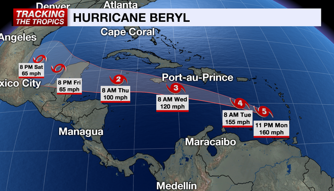
As of 11 p.m. Monday, the National Hurricane Center says Beryl is now a powerful and dangerous Category 5 storm with winds at 160 mph and gusting to 195 mph. This is the earliest Category 5 storm ever recorded and only the second July storm to ever reach Category 5 status. Hurricane Emily in 2005 had the previous record of earliest hurricane to reach Cat 5 status on July 17.
Beryl's forward speed is being pegged at 22 mph to the west-northwest. Its latest pressure reading was 944 mb, down from Monday morning.
Hurricane Beryl's strengthening is compliments of an environment of unusually low wind shear and record-warm water temperatures for early July.
On Monday morning, the storm made landfall on Carriacou Island with 150 mph winds as gauged by Hurricane Hunter aircraft.
Beryl may even increase its strength slightly within the next 24 hours before encountering some wind shear. Some gradual weakening is forecast by Wednesday once the storm moves into the less favorable, highly sheared environment.
A strong bubble of high pressure over the southern U.S. will keep the storm moving west through the Caribbean, preventing the storm from turning north toward Florida and the southeast.
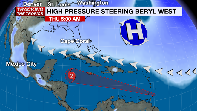
Beryl is forecast to move toward the Yucatan peninsula by the weekend and then possibly into the Gulf of Mexico. The question is what the state of the storm at that point after dealing with a more hostile environment over the western Caribbean. It's too early to speculate whether or not the storm will impact the western U.S. Gulf Coast, but the trend has been for it to track closer to Mexico.
It is extremely rare to see a major hurricane develop this far east in the Atlantic Basin this early in the season. Beryl broke the record for the easternmost hurricane development during June in the Atlantic, and was also the first Category 4 hurricane to develop in June.
Typically, development in the early months of hurricane season is weaker and closer to home. The average first hurricane of the Atlantic season is August 11, so we are already running far ahead of schedule.
Stay prepared throughout hurricane season by checking in on your hurricane plans and frequently checking the forecast. Count on the NBC2 Hurricane Tracking Team to keep you informed.
Follow the NBC2 weather team on social media
- Chief Meteorologist Allyson Rae on Facebook and Twitter
- Meteorologist Jason Dunning on Facebook and Twitter
- Meteorologist Rob Duns on Facebook and Twitter
- Meteorologist Justin Hobbs on Facebook and Twitter
- Meteorologist Lauren Hope on Facebook and Twitter
Watch our forecasts on TV or online
Here's where to find our latest video forecast . You can also watch a livestream of our latest newscast here .
Download our free NBC2 News app for the latest
Here is where you can download our app for the latest weather alerts .