
As of 8 a.m. on Sunday, Tropical Storm Debby has strengthened with winds now sustained at 60 mph. The storm is tracking north-northwest at 13 mph. As the storm continues to move further into the warm Gulf of Mexico, strengthening is projected.
The latest forecast projects Debby to become a Category 1 Hurricane by Monday with winds of 85 mph as it moves into the Big Bend region. Hurricane Hunters are scheduled to investigate the system today.
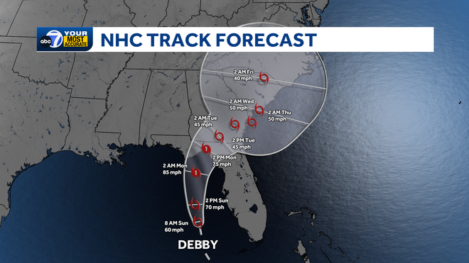
It is expected to strengthen into a Cat. 1 hurricane prior to moving onshore.
A Tropical Storm Warning is in effect for coastal Collier, Lee, and Charlotte counties, up to Englewood, which means tropical storm conditions are expected within the next 36 hours.
A Tropical Storm Watch is in effect for inland Lee, Charlotte, and DeSoto counties where tropical storm conditions are possible.
A Flood Watch is also in effect for parts of Southwest Florida, including DeSoto, Charlotte and Lee Counties through Monday night— as well as all of Collier, Glades, and Hendry counties through Sunday night.
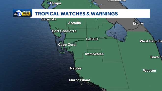
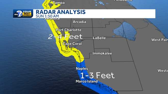
A Storm Surge Watch is in effect for coastal Lee and Charlotte counties. Onshore winds may also produce higher tides and a peak storm surge of 1-4 feet. Homes and businesses near the coast should especially watch for flooding during high tide Sunday morning.
Our timeline for impacts of heavy rainfall, gusty winds and potentially some coastal flooding will be when this system makes its closest pass to SWFL through the morning.
The storm will bring several inches of rain and tropical storm-force winds. For now, the main impact on our community looks to be heavy downpours which could cause some flooding in poor drainage areas.
Rainfall from this system has the potential to bring 4-6 inches through Monday. However, it's possible that parts of South Florida could see 6-8+ inches of rain depending on where the heavier rain bands set up. This would be nearly a month's worth of rainfall in only 48 hours!
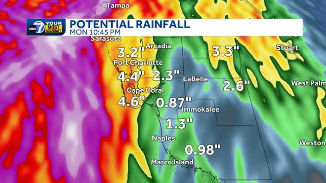
Excessive runoff may result in minor flooding of rivers, creeks, streams and other low-lying and flood-prone locations.
Although we don't expect this to be a major wind event for us, a faster-forming storm could bring tropical storm-force winds to portions of the area, with gusts above 40 mph near the coast.
After landfall in the Big Bend by Monday morning, the system, the system will bring heavy rain and gusty winds to Georgia and South Carolina.
Stay with ABC7 for the latest updates as additional watches and warnings are issued.
Follow the ABC7 weather team on social media
- Chief Meteorologist John Patrick on Facebook and X
- Meteorologist Jim Dickey on Facebook and X
- Meteorologist Jesslyn Ferentz on Facebook and X
- Meteorologist Sami Squires on Facebook and X
Watch our forecasts on TV or online
- Here's where to find our latest video forecast .
- You can also watch a livestream of our latest newscast here
Download our free ABC7 News app for the latest.