Viewer question: Why is Hurricane Helene expected to move faster than Hurricane Ian?
That's a great question. Storm surge values were so deep in our community during Hurricane Ian because not only did the storm make landfall in our area, it was also very slow moving.
Ian's forward speed on Sept. 28, 2022, was less than 10 mph thanks to the steering currents around it.
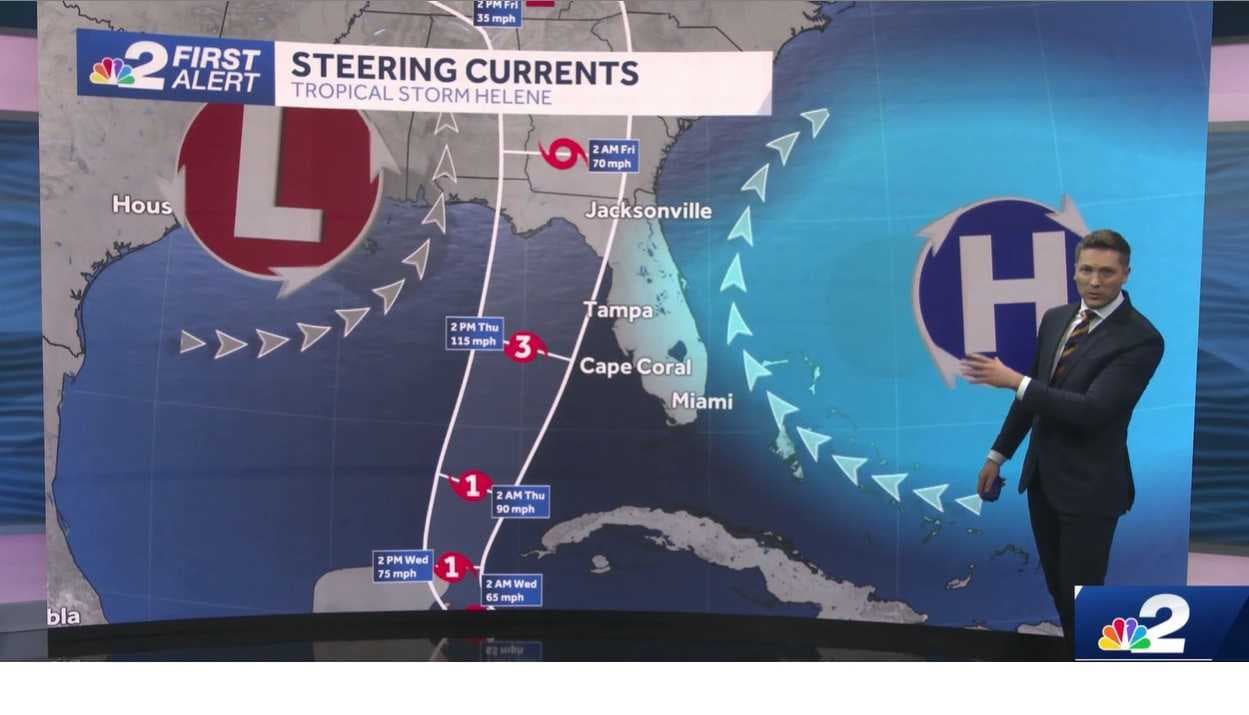
Despite the fast winds that hurricanes generate, they don't push themselves across the ocean. Instead, like a spinning top, they need to be pushed by winds in the atmosphere around them to move one way or another.
Hurricane Helene is being steered primarily by two pressure influences. The first is a ridge of high pressure to the east of Florida. The second is a somewhat cut-off area of low pressure in the mid-levels of the atmosphere to the west of Florida.
As you can see in the image below, air flows clockwise around areas of high pressure and counter-clockwise around areas of low pressure.

The combination of these two pressure features is opening up a speedier pathway for Helene to follow than Hurricane Ian had.
Hurricane Ian didn't have that spinning mid-level cut-off area of low pressure to its west, so instead of picking up in forward speed, it moved much more slowly around the ridge of high pressure over the Atlantic Ocean.
Though Hurricane Helene is forecast to be a much faster storm than Hurricane Ian, it is still bringing a significant storm surge risk to our community.
A storm surge warning is active for all of Southwest Florida's coastline. The National Weather Service's definition of a storm surge warning is "life-threatening inundation from rising water moving inland from the shoreline somewhere within the specified area, generally within 36 hours."
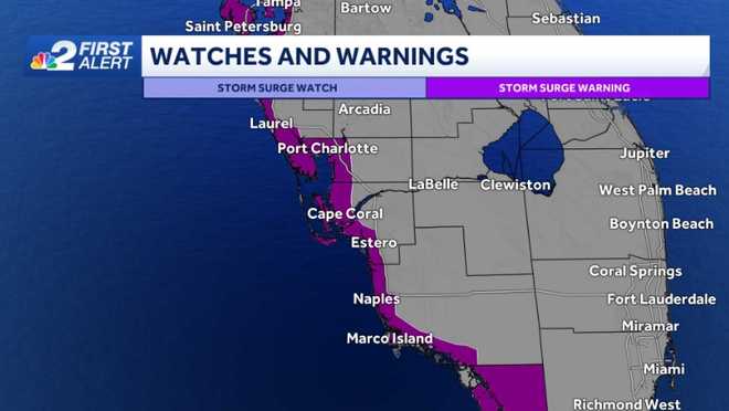
The current forecast from the National Hurricane Center calls for peak storm surge forecast values somewhere along the immediate coastline of 4 to 7 feet north of Englewood, with 3 to 5 feet possible from Englewood to south of Marco Island in Collier County.
These values are most likely to occur if the strongest onshore winds happen during periods of high tide Thursday morning.
Because of the threat of storm surge, evacuations have been ordered (so far) in Charlotte County for the region's barrier islands and low-lying flood-prone regions.
If you live in a storm surge-prone area of our coast and have experienced coastal flooding during smaller hurricanes in the last few years it would be advised you find a safer place to stay Thursday that is off the barrier islands and immediate coastline.
NBC2 News will continue to keep you updated as Helene gets closer to our community.
DOWNLOAD the free NBC2 News app for your latest news and weather alerts.