
With news breaking on Thursday morning that the drought along the Gulf Coast of South Florida is the worst in 24 years , you might be curious as to how that determination is made.
That's because the U.S. drought monitor is different than other weather scales.
During hurricane season, for instance, the Saffir-Simpson scale uses five levels to categorize the intensity of a hurricane.
The determination is cut and dry.
When a storm has sustained winds between 74 and 95 mph, it's a category 1. When it has sustained winds of 96 to 110 mph, it's a category 2, and so on.
The classification in this case is based solely on a number. It doesn't matter if the storm is thousands of miles away from the coast or making landfall, the number is the number.
The U.S. drought monitor on the other hand is more nuanced. Of course the people who hand draw its contours consider things like how much of a rain deficit an area has, but they also look beyond the numbers.
When illustrating the data is updated, the U.S. drought monitor utilizes a Venn diagram. That's an illustrative tool using circles to explain how multiple factors contribute to a common item.
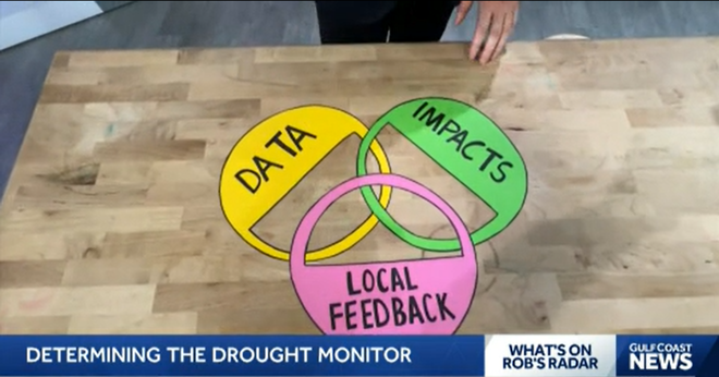
The first of the three circles in the drought monitor diagram is data like rainfall figures, or the amount an area is in a deficit.
The second circle is focused around impacts. Some of the most notable impacts are monitoring river and reservoir levels and the intensity and frequency of wildfires in an area. They're the symptoms of a drought, and the more they are impacted, the worse the drought is.
The third circle is based around local feedback. A human touch, if you will. The people who build each week's drought monitor stay in communication with people on the ground in the areas being affected by drought.
State climatologists and people like farmers have invaluable insight into how bad a drought is and how it compares to years past.
The combination of factors helps determine a comprehensive view of how intense a drought it, making it different from other commonly used weather scales.
Follow the Gulf Coast Storm Team on social media
- Chief Meteorologist Allyson Rae on Facebook and X
- Meteorologist Jim Dickey on Facebook and X
- Meteorologist Jason Dunning on Facebook and X
- Meteorologist Rob Duns on Facebook and X
- Meteorologist Jesslyn Ferentz on Facebook and X
- Meteorologist Lauren Hope on Facebook and X
- Meteorologist Raphael Tavernier on Facebook and X
Watch your Gulf Coast Weather forecasts on TV or online
- Here's where to find our latest video forecast
- You can also watch a live stream of our latest newscast here
DOWNLOAD the free Gulf Coast News app for your latest breaking news and weather alerts.