Fox4Now
Melissa is the third strongest hurricane on record in the Atlantic
Fox4Now Staff
•10/28/2025
Source: Fox4Now
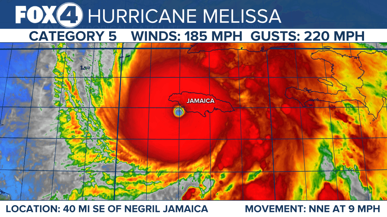
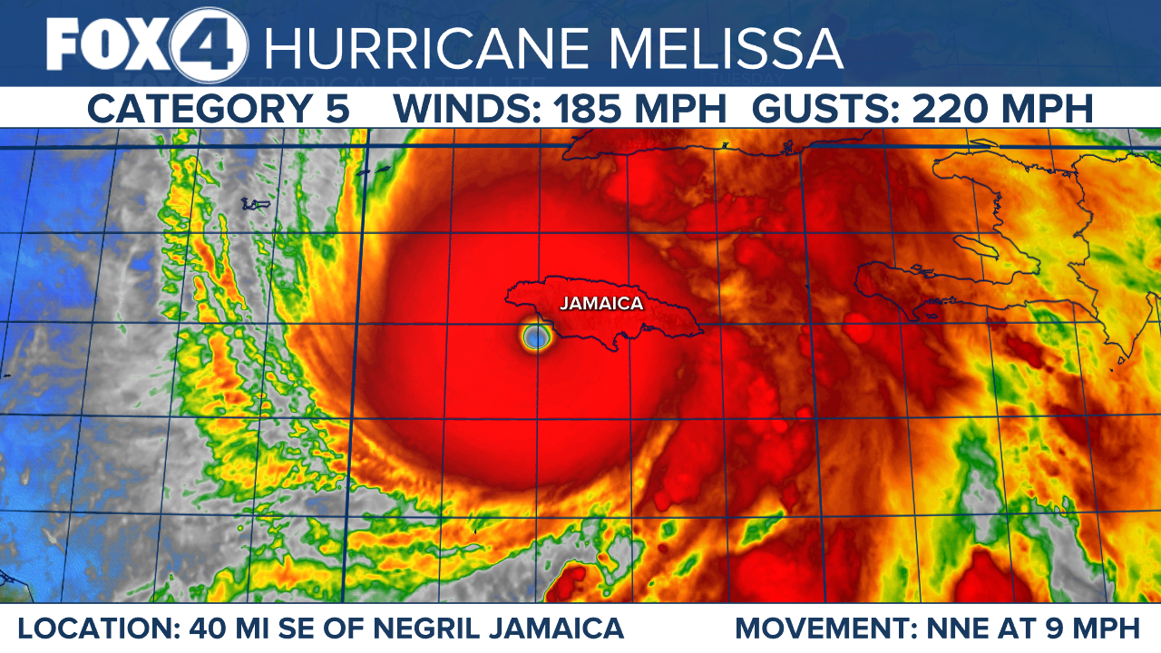
Maximum sustained winds are near 185 mph with higher gusts up to 220mph. Melissa is a category 5 hurricane on the Saffir-Simpson Hurricane Wind Scale.
The estimated minimum central pressure is 892 mb making Melissa the third strongest hurricane in the Atlantic basin.
Some fluctuations in intensity are likely before Melissa makes landfall on Jamaica later today. However, Melissa is expected to reach Jamaica and southeastern Cuba as an extremely powerful major hurricane, and will still be at hurricane strength when it moves across the southeastern Bahamas.
WFTX
Hurricane-force winds extend outward up to 30 miles from the center and tropical-storm-force winds extend outward up to 195 miles.
Melissa is moving toward the north-northeast near 9 mph. A turn toward the northeast with an increase in forward speed is expected today, followed by a faster northeastward motion on Wednesday and Thursday.
On the forecast track, the core of Melissa is expected to move near or over Jamaica, across southeastern Cuba Wednesday morning, and across the southeastern or central Bahamas later on Wednesday.
Jamaica:
Remain in your safe shelter and do not venture outside. Catastrophic, life-threatening flash flooding and numerous landslides are expected through Tuesday. Rainfall totals of 15 to 30 inches across Jamaica through Wednesday, with local maximum amounts potentially reaching 40 inches.
Peak storm surge heights could reach 9 to 13 feet above ground level, near and to the east of where the center of Melissa makes landfall. This storm surge will be accompanied by large and destructive waves. On the northwest coast of Jamaica, near Montego Bay, there is the possibility of 1 to 3 feet of storm surge above ground level.
The eyewall’s destructive winds may cause total structural failure, particularly in higher elevations, leading to widespread infrastructural damage, prolonged power and communication outages, and isolated communities. Along the southern coast, life-threatening storm surge and damaging waves are anticipated through Tuesday.
Haiti and the Dominican Republic:
Additional rainfall of 6 to 12 inches for southern Hispaniola through Wednesday may lead to life-threatening flash flooding and landslides across southwestern Haiti and southern portions of the Dominican Republic through midweek. In Haiti, extensive infrastructural damage and isolation of communities is likely. Tropical storm conditions are expected late Tuesday and Wednesday.
Eastern Cuba:
Heavy rainfall with life-threatening and potentially catastrophic flash flooding and landslides is expected to begin tonight. Life-threatening storm surge and damaging winds are expected late Tuesday and Tuesday night. For eastern Cuba, storm total rainfall of 10 to 20 inches, with local amounts to 25 inches, is expected by Monday into Wednesday resulting in life-threatening and potentially catastrophic flash flooding with numerous landslides.
There is a potential for significant storm surge along the southeast coast of Cuba late Tuesday or Wednesday. Peak storm surge heights could reach 7 to 11 feet above normal tide levels, near and to the east of where the center of Melissa makes landfall. This storm surge will be accompanied by large and destructive waves. Preparations should be rushed to completion.
Southeast and Central Bahamas and the Turks and Caicos:
Hurricane conditions, life-threatening storm surge, and heavy rainfall are expected across portions of the southeast and central Bahamas on Wednesday. Storm surge of 4 to 6 ft above normally dry ground is possible in the southeastern Bahamas and Turks and Caicos Islands on Wednesday.
Over the Southeast Bahamas, total rainfall of 5 to 10 inches is expected Tuesday into Wednesday resulting in areas of flash flooding.
Residents should follow advice given by local officials and be sure to have preparations complete by Tuesday night. Tropical storm conditions, heavy rains, and a significant storm surge is expected in the Turks and Caicos Islands on Wednesday.
Warnings and watches in effect

A Hurricane Warning is in effect for Jamaica, Cuban provinces of Granma, Santiago de Cuba, Guantanamo, and Holguin, Southeastern and Central Bahamas. A Hurricane Warning means that hurricane conditions are expected somewhere within the warning area. A warning is typically issued 36 hours before the anticipated first occurrence of tropical-storm-force winds, conditions that make outside preparations difficult or dangerous. Preparations to protect life and property should be complete in Jamaica and rushed to completion in Cuba.
A Hurricane Watch is in effect for Turks and Caicos Islands. A Hurricane Watch means that hurricane conditions are possible within the watch area. A watch is typically issued 48 hours before the anticipated first occurrence of tropical-storm-force winds, conditions that make outside preparations difficult or dangerous.
A Tropical Storm Warning is in effect for Haiti, Cuban province of Las Tunas, Turks and Caicos Islands. A Tropical Storm Warning means that tropical storm conditions are expected somewhere within the warning area within 36 hours.
Interests in Bermuda should monitor the progress of Melissa.
Share: