Local News
Red Flag Warning: Gusty Winds and Lack of Humidity bring Critical Fire to the Gulf Coast
Sara Blue
•4/21/2026
Source: Gulf Coast News Now

The Gulf Coast Storm Team has declared today and Wednesday Gulf Coast Weather Impact Days for high fire danger. Dry air and breezy winds have sparked critical fire danger across most of the Gulf Coast. That is a level 2 out of 3 fire risk.
Gusty winds will howl out of the northeast between 25 and 30 mph today. Those winds will also usher in a shot of dry air, dropping afternoon relative humidity values toward and below 30%.
As such, a rare Red Flag Warning has been issued by the National Weather Service for all of Southwest Florida today. That means any fire that sparks can spread incredibly quickly.
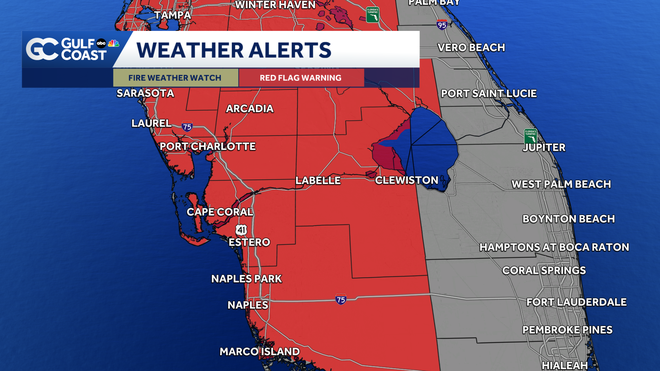
Outdoor burning or use of open flames is highly discouraged today. Remember to check your tow chains and properly dispose of cigarettes and matches to minimize sparks.
Aside from the high fire danger, Tuesday will feature mostly sunny skies and highs in the mid 80s. Temperatures will dive to the mid 60s and upper 50s by sunrise tomorrow morning.
High fire danger lingers into Wednesday. Humidity mixes back in later this week, helping to bring our fire danger down. Rain chances will look to remain quite low through the rest of the week and weekend.
What is a Gulf Coast Weather 'Impact Day?'
Southwest Florida residents will see visual warnings on their daily Gulf Coast weather forecasts on air and online, designed to signal if weather may disrupt their daily life or pose a serious threat.
The Gulf Coast Weather team introduced two new categories, impact days and alert days, using yellow and red symbols to flag the potential for inconvenience or danger.
These icons are designed to provide an at-a-glance understanding of how the day’s forecast may impact commutes, outdoor plans or personal safety. The alerts will appear on TV forecasts and digital platforms to help you make informed decisions throughout the day.
Impact Day: Yellow symbol flags likely disruptions
A yellow triangle with an exclamation mark will now appear on forecasts for days when the weather is expected to interrupt normal routines. These are not extreme conditions but can still cause problems, especially during peak travel times, holidays, or for outdoor work and activities.
For example, dense morning fog or afternoon storms might slow down traffic, create slick roads and disrupt plans. The symbol is also used for days with moderate cold or heat that may limit time spent outside.
Examples of Gulf Coast Weather Impact Day weather:
- Rain or storms that may limit outdoor activity, travel or holiday plans
- Strong storms during a morning or evening commute
- Dense fog reducing visibility across major roads
- Moderate cold or summer heat that limits outdoor activity
- Burn bans caused by dry weather and strong wind gusts
Alert Day: Red symbol warns of severe or dangerous weather
When more serious threats are expected, a red circle icon will appear on forecasts, warning viewers that the weather could become life-threatening. These are days when preparation is essential and residents should monitor forecasts closely for updates.
The red alert may be issued for an entire day or just for high-risk time periods, such as a thunderstorm threat in the late afternoon.
Examples of Gulf Coast Weather Alert Day weather:
- Tornado threats or severe thunderstorms with damaging winds or hail
- Flash flooding or widespread flooding from heavy rain
- Hurricanes or tropical storms threatening the region
- Extreme heat or cold creating health and safety risks
These icons are designed to provide you with clear and timely information about potential weather risks. The weather team encourages everyone to use the symbols as a cue to check the forecast more closely and plan accordingly.
However you watch or scroll, we're committed to delivering your Gulf Coast Weather Most Accurate Forecast, one you can rely on every day, wherever you are.
Live Interactive Radar: Track conditions in real time with the Gulf Coast Live Radar.
Watch Gulf Coast Weather: Find the latest weather forecast videos, streaming live or on demand, on TV and online.
Stream on the Go: Download the free Gulf Coast News app to watch on your phone or tablet.
Your Gulf Coast Weather Team
- Chief Meteorologist Allyson Rae
- Meteorologist Caroline Castora
- Meteorologist Jim Dickey
- Meteorologist Lauren Hope
- Meteorologist Raphael Tavernier
- Meteorologist Rob Duns
- Meteorologist Sara Blue
Follow on Social: Follow, like and subscribe to Gulf Coast News on social media to share your tips and be part of the conversation with Southwest Florida's most experienced, trusted weather team: Facebook | Instagram | YouTube | TikTok | Threads | Bluesky | Nextdoor | X
Share: